[{"id":160211992676,"handle":"all-products","title":"All Products","updated_at":"2026-07-19T12:01:40+01:00","body_html":"","published_at":"2020-05-12T10:33:34+01:00","sort_order":"manual","template_suffix":"","disjunctive":true,"rules":[{"column":"tag","relation":"equals","condition":"Cornwall and Scilly guidebooks"},{"column":"tag","relation":"equals","condition":"Maps and Pocket Guides"}],"published_scope":"web","image":{"created_at":"2023-04-14T16:46:57+01:00","alt":null,"width":4000,"height":2630,"src":"\/\/www.friendly-guides.uk\/cdn\/shop\/collections\/godrevy-gwithian-baech-st-ives-cornwall-friendly-guides.jpg?v=1681487217"}},{"id":29948295,"handle":"isles-of-scilly","updated_at":"2026-07-19T12:01:40+01:00","published_at":"2014-10-26T09:40:00+00:00","sort_order":"manual","template_suffix":"","published_scope":"web","title":"Isles of Scilly","body_html":"If you’re visiting Scilly for the first time, we recommend trying our \u003cstrong\u003eIsles of Scilly Guidebook\u003c\/strong\u003e and \u003cstrong\u003eIsles of Scilly Map\u003c\/strong\u003e as they give a good overview of the whole group. Each inhabited island is also covered by a superscale (1:10,000) \u003cstrong\u003eScilly Pocket Map\u003c\/strong\u003e and a \u003cstrong\u003eScilly Island by Island\u003c\/strong\u003e book – they are packed with photos, detailed descriptions and walks. Both can be purchased as \u003cstrong\u003ecollections\u003c\/strong\u003e.","image":{"created_at":"2023-03-22T18:49:07+00:00","alt":"A couple sit on the beach looking over Great Par","width":3840,"height":2160,"src":"\/\/www.friendly-guides.uk\/cdn\/shop\/collections\/isles-of-scilly-381296.jpg?v=1681486658"}},{"id":30188059,"handle":"maps-and-pocket-guides","updated_at":"2026-07-19T12:01:40+01:00","published_at":"2020-04-01T18:09:00+01:00","sort_order":"manual","template_suffix":"","published_scope":"web","title":"Maps and Pocket Guides","body_html":"\u003cp\u003e\u003cspan style=\"color: #000000;\"\u003eOur Pocket Guides are a combination of map and guide. Superscale maps show local footpaths, cafes, pubs, loos, ancient sites, nature trails and ferry landing places. They tell you the best places and beaches to visit, plus the best local walks. So whether you live locally or are planning a visit, we will help you get the most fun and interest out of exploring an area.\u003c\/span\u003e\u003c\/p\u003e","image":{"created_at":"2023-03-22T18:49:11+00:00","alt":"Maps and Pocket Guides - Friendly Guides","width":3846,"height":1850,"src":"\/\/www.friendly-guides.uk\/cdn\/shop\/collections\/maps-and-pocket-guides-109303.jpg?v=1679510951"}}]
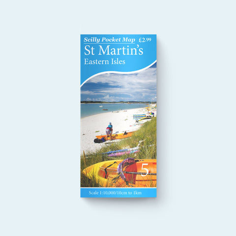
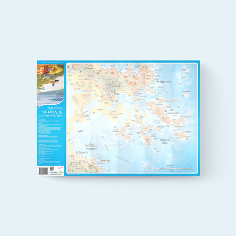
No other island on Scilly offers such contrasting faces to the world. Its south-facing hillsides are natural sun-traps and the gardens are full of subtropical plants. The north coast is much wilder, forming a dramatic backdrop to the popular beaches in St Martin’s Bay. Includes a map of the Eastern Isles popular with sightseeing boat trips and landings at Great Arthur, Nornour and Great Ganilly.
Just what we were looking for! Everything you need to know as a taster before our visit to the island.
S
Stewart Short
Map
Excellent maps , especially for birders visiting the islands
A
Archie
Five Stars
Perfect for our trip
S
Sarah Barrett
Good map
good portable map with excellent detail on it. I am really looking forward to checking out the accuracy next summer.
W
WFC
Best Map for the Islands
Easy to carry fold away map with all the details you need to get around the islands. One side has the island in question, the backside shows an overview of all the islands (which you can see from the coastline).
Popup
Stay up to date on the latest product releases, special offers & news by signing up for our newsletter.