[{"id":160211992676,"handle":"all-products","title":"All Products","updated_at":"2026-06-13T12:01:47+01:00","body_html":"","published_at":"2020-05-12T10:33:34+01:00","sort_order":"manual","template_suffix":"","disjunctive":true,"rules":[{"column":"tag","relation":"equals","condition":"Cornwall and Scilly guidebooks"},{"column":"tag","relation":"equals","condition":"Maps and Pocket Guides"}],"published_scope":"web","image":{"created_at":"2023-04-14T16:46:57+01:00","alt":null,"width":4000,"height":2630,"src":"\/\/www.friendly-guides.uk\/cdn\/shop\/collections\/godrevy-gwithian-baech-st-ives-cornwall-friendly-guides.jpg?v=1681487217"}},{"id":30188059,"handle":"maps-and-pocket-guides","updated_at":"2026-06-07T12:03:25+01:00","published_at":"2020-04-01T18:09:00+01:00","sort_order":"manual","template_suffix":"","published_scope":"web","title":"Maps and Pocket Guides","body_html":"\u003cp\u003e\u003cspan style=\"color: #000000;\"\u003eOur Pocket Guides are a combination of map and guide. Superscale maps show local footpaths, cafes, pubs, loos, ancient sites, nature trails and ferry landing places. They tell you the best places and beaches to visit, plus the best local walks. So whether you live locally or are planning a visit, we will help you get the most fun and interest out of exploring an area.\u003c\/span\u003e\u003c\/p\u003e","image":{"created_at":"2023-03-22T18:49:11+00:00","alt":"Maps and Pocket Guides - Friendly Guides","width":3846,"height":1850,"src":"\/\/www.friendly-guides.uk\/cdn\/shop\/collections\/maps-and-pocket-guides-109303.jpg?v=1679510951"}},{"id":29908355,"handle":"west-cornwall","updated_at":"2026-06-11T12:01:49+01:00","published_at":"2014-10-25T20:37:00+01:00","sort_order":"manual","template_suffix":"","published_scope":"web","title":"West Cornwall","body_html":"The Lizard and Land’s End peninsulas are two of Cornwall’s most distinctive places. They jut so far into the ocean they have to bend to its moods, alternately battered by gales and enveloped in sea mists. The moors and roughhewn cliffs are peppered with prehistoric tombs and provide the backdrop to some of Cornwall’s finest beaches like Kynance, Sennen and Porthcurno.","image":{"created_at":"2023-03-22T18:49:28+00:00","alt":"A photo of Gunwalloe Beach at low tide with RNLI lifeguard flags","width":3813,"height":2145,"src":"\/\/www.friendly-guides.uk\/cdn\/shop\/collections\/west-cornwall-993131.jpg?v=1679576019"}}]
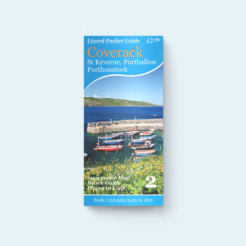
Lizard Pocket Guide 2 - Coverack, St Keverne, Porthallow, Porthoustock
£2.99
2 reviews
This pocket guides starts at Porthallow and covers the area south to Porthkerris, Porthoustock and Coverack Cove, Downas Cove, Lankidden and Kennack Sands. Inland the map includes St Keverne and Roskilly’s (famous for their ice cream) and the beautiful serpentine heaths of Main Dale and Crousa Downs. Superscale map with guide to the best beaches, walks and places to visit.