[{"id":160211992676,"handle":"all-products","title":"All Products","updated_at":"2026-07-19T12:01:40+01:00","body_html":"","published_at":"2020-05-12T10:33:34+01:00","sort_order":"manual","template_suffix":"","disjunctive":true,"rules":[{"column":"tag","relation":"equals","condition":"Cornwall and Scilly guidebooks"},{"column":"tag","relation":"equals","condition":"Maps and Pocket Guides"}],"published_scope":"web","image":{"created_at":"2023-04-14T16:46:57+01:00","alt":null,"width":4000,"height":2630,"src":"\/\/www.friendly-guides.uk\/cdn\/shop\/collections\/godrevy-gwithian-baech-st-ives-cornwall-friendly-guides.jpg?v=1681487217"}},{"id":29948295,"handle":"isles-of-scilly","updated_at":"2026-07-19T12:01:40+01:00","published_at":"2014-10-26T09:40:00+00:00","sort_order":"manual","template_suffix":"","published_scope":"web","title":"Isles of Scilly","body_html":"If you’re visiting Scilly for the first time, we recommend trying our \u003cstrong\u003eIsles of Scilly Guidebook\u003c\/strong\u003e and \u003cstrong\u003eIsles of Scilly Map\u003c\/strong\u003e as they give a good overview of the whole group. Each inhabited island is also covered by a superscale (1:10,000) \u003cstrong\u003eScilly Pocket Map\u003c\/strong\u003e and a \u003cstrong\u003eScilly Island by Island\u003c\/strong\u003e book – they are packed with photos, detailed descriptions and walks. Both can be purchased as \u003cstrong\u003ecollections\u003c\/strong\u003e.","image":{"created_at":"2023-03-22T18:49:07+00:00","alt":"A couple sit on the beach looking over Great Par","width":3840,"height":2160,"src":"\/\/www.friendly-guides.uk\/cdn\/shop\/collections\/isles-of-scilly-381296.jpg?v=1681486658"}},{"id":30188059,"handle":"maps-and-pocket-guides","updated_at":"2026-07-19T12:01:40+01:00","published_at":"2020-04-01T18:09:00+01:00","sort_order":"manual","template_suffix":"","published_scope":"web","title":"Maps and Pocket Guides","body_html":"\u003cp\u003e\u003cspan style=\"color: #000000;\"\u003eOur Pocket Guides are a combination of map and guide. Superscale maps show local footpaths, cafes, pubs, loos, ancient sites, nature trails and ferry landing places. They tell you the best places and beaches to visit, plus the best local walks. So whether you live locally or are planning a visit, we will help you get the most fun and interest out of exploring an area.\u003c\/span\u003e\u003c\/p\u003e","image":{"created_at":"2023-03-22T18:49:11+00:00","alt":"Maps and Pocket Guides - Friendly Guides","width":3846,"height":1850,"src":"\/\/www.friendly-guides.uk\/cdn\/shop\/collections\/maps-and-pocket-guides-109303.jpg?v=1679510951"}}]
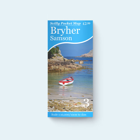
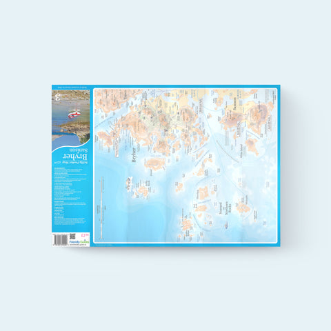
Bryher has some of the most beautiful coastal scenery in Scilly and along with neighbouring Samson has a naturally rough-hewn character from standing on the exposed western edge of the islands. Although Samson is uninhabited it's a popular place to visit – you can wander around abandoned houses and prehistoric tombs or picnic on the beach at East Porth. This pocket maps shows all the footpaths, places to visit, loos and cafes from Hell Bay to Badplace Hill.
An ideal companion for a visit to Bryher, a small island with a lot to explore.
A
April Tarling
Detailed, fascinating map
Just off to visit Bryher and your maps and guide book are just what we were looking for. We’re really going to enjoy exploring with them.
M
Mark Spitzer
Lovely clear map
A wonderful souvenir. Large scale and clear-very easy to study and enjoy
J
Julie Furniss
Bryer and Samson - excellent map
Easy map to follow and folds away perfectly into a pocket. Covered ours with clingfilm on wet days. Highly recommend map and Friendly Guides UK as a company. Excellent service and speedy delivery. Great value for money.
Popup
Stay up to date on the latest product releases, special offers & news by signing up for our newsletter.